Showing 108 items matching stage one buildings
-
 Federation University Historical Collection
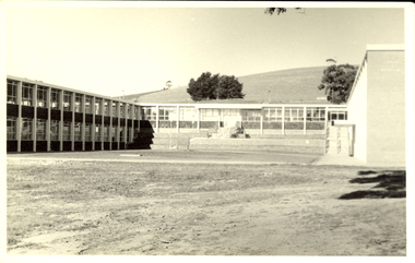
Photograph, Mount Helen Campus Stage One Buildings, c1970
... Mount Helen Campus Stage One Buildings...Stage one buildings... One Buildings... Photograph Mount Helen Campus Stage One Buildings Black and white ...Black and white photograph of the Mount Helen Campus Stage One Buildingsstage one buildings, buildings, f building, g building -
 Federation University Historical Collection
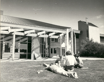
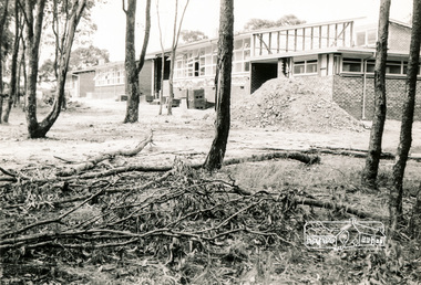
Photograph, Mount Helen Campus Stage One Buildings, 1974
... Mount Helen Campus Stage One Buildings...Photos of the Mount Helen Campus Stage One Buildings... Photograph Mount Helen Campus Stage One Buildings Photos of the Mount ...Photos of the Mount Helen Campus Stage One Buildingsbuildings, mount helen campus, library, e.j. barker library, e building -
 Federation University Historical Collection
Photograph - Photograph - black and white, Mount Helen Campus Union Building, c1980
... stage one buildings... union building albert coates complex footbridge stage one ...Photograph of the Mt Helen Campus, including the library, Union Buildingmount helen campus, buildings, e.j. barker library, union building, albert coates complex, footbridge, stage one buildings -
Federation University Historical Collection
Photograph, Official Opening of Stage 1 Buildings on Mount Helen Campus, 1970, 31/10/1970
... Stage one buildings... opening Stage one buildings Morgan B. John M.B. John E.J. Barker ...Official Opening of Stage 1 Buildings on Mount Helen Campus by The Hon. Nigel Bowennigel bowen, mount helen campus, opening, stage one buildings, morgan b. john, m.b. john, e.j. barker, jack barker, dudley erwin, rolly parfenovics, w.g. durant, bill durant, harold arblaster -
Federation University Historical Collection
Photograph, Turning of the Sod on Mount Helen Campus, 31/10/1970
... stage one buildings.... Nigel Bowen mount helen campus stage one buildings morgan b ...Turning of the Sod on Stage 1 Buildings on Mount Helen Campus by The Hon. Nigel Bowenmount helen campus, stage one buildings, morgan b. john, m.b. john, e.j. barker, jack barker, nigel bowen, kaye barry -
 Federation University Historical Collection
Photograph - Black and White, Bill Durant (probably), Mount Helen Campus, 1970, c1970
... Views of the Stage one buildings on the Mount Helen Campus... of the Stage one buildings on the Mount Helen Campus This photograph ...This photograph was most probably taken by lecturer Bill Durant who was a staff member on the Mount Helen Campus from 1970Views of the Stage one buildings on the Mount Helen Campusfederation university, federation university australia, feduni, ballarat institute of advanced education, durant -
 Federation University Historical Collection
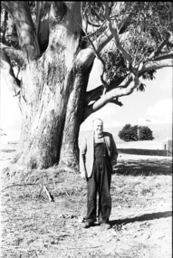
Photograph - black and white, Mr Downing by the Federation University Tree of Knowledge, 1970
... University Tree of Knowledge. Stage one buildings on the Mount Helen... the Federation University Tree of Knowledge. Stage one buildings ...Federation University Mount Helen Campus was open to students in 1970. In that year Mr Dowling as photographed beside a big Tasmanian bluegum which was used a the centre Mount Helen Campus concept plan, and later became known as the Tree of Knowledge. Mr Dowling watered the tree after it was planted by his mother, Elizabeth Downing, on Arbour Day 1896. Mrs Downing raised her large family on the site of the Mount Helen Campus, which included an orchard and milking cows. The Tree of Knowledge is actually two trees, the trunks have fused together over time, and there is further evidence of fusion. The Downing farmhouse was situated in the vicinity of the present Administration and Caro Conference Centre buildings and the tree was planted beside the "dunny". It was carefully watered by the nine Downing children from a brick-lined well situated under what is now the Albert Coates Building. As the tree grew to maturity, it was used to hang a meat safe after slaughtering a sheep for the family table. Some years ago, when the foundations were being dug for the E-Building, an old rusted percussion pistol was found. One of Mrs Downing's sons, at that time well into his nineties, remembered getting into trouble for playing with it without permission, and losing it. The land was purchased in 1966 as part of a 241-acre site for Ballarat's new tertiary institution. When the architects and planners inspected the site, they decided "The Big Tree" must remain as a central landmark in preparing the layout of the campus amenities. In 1982, the spread of the tree was 36 metres, girth 7 metres, and height 36 metres. By 2003 the spread was 39.5 metres (N-S) and 35.5 metres (E-W), girth 7.75 metres, and height 42.5 metres. A man in overalls and jacket stands beside the Federation University Tree of Knowledge. Stage one buildings on the Mount Helen Campus are evident in the background.elizabeth downing, downing, tree of knowledge, big tree, mount helen campus, mount helen -
 Federation University Historical Collection
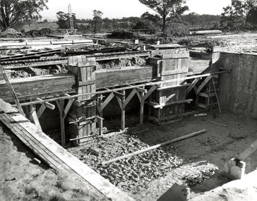
Photograph, N.l. Harvey & Son, Mount Helen Campus, 1968, 1969
... Seven photographs of the Mt Helen Campus Stage one... building. .13) Mt Helen development Stage One, Engineering Diploma ...The Federation University campus at Mount Helen was first used by students in 1970.Seven photographs of the Mt Helen Campus Stage one development. .1) Aerial view of foundation work, from west, towards Green Hill .2) Aerial View from South. Earthworks and foundations .3) Aerial View from south west. Earthworks, general view .4) Aerial View from above the South West corner of E building. .5) Aerial View from North East. Gear Avenue in background .6) Aerial View from North West. Earthworks extend from Gear Avenue .7) Ground level view. First columns of E building. .13) Mt Helen development Stage One, Engineering Diploma Buildings. This image shows the wall beam and pier construction to the East Wall of the Fluid Mechanics Laboratory adjacent to the pump chamber, 17 June 1968. .18) Flume Pit and Pump Chamber, 15 July 1968. .28) East Wing Pit Looking North, 26 August 1968 .40) Construction as of 04 November 1968federation university, federation university australia, feduni, university of ballarat, ballarat college of advanced education, ballarat institute of advanced education, building, earthworks, foundation, early development, soil testing laboratory -
 Federation University Historical Collection
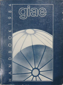
Book, Gippsland Institute of Advanced Education Handbooks, 1970-1985
.1) 1977 Gippsland Institute of Advanced Education Handbook with white cover .2) 1978 Gippsland Institute of Advanced Education Handbook with blue/black cover .3) 1979 Gippsland Institute of Advanced Education Handbook with orange cover .4) 1980 Gippsland Institute of Advanced Education Handbook with yellow/brown cover .5) 1981 Gippsland Institute of Advanced Education Handbook with grey/black cover .6 1984 Gippsland Institute of Advanced Education Handbook with blue cover .7) 1985 Gippsland Institute of Advanced Education Handbook with purple cover .8) 1989 Gippsland Institute of Advanced Education Handbook with white/purple/grey/red/blue cover .7) 1985 Gippsland Institute of Advanced Education Handbook with pale green cover. .9) 1974 Gippsland Institute of Advanced Education Handbook with orangeand white cover .10) 1975 Gippsland Institute of Advanced Education Handbook with green and white cover .11) 1976 Gippsland Institute of Advanced Education Handbook with white cover .12) 1986 Gippsland Institute of Advanced Education Handbook with mid-blue cover .13) 1987 Gippsland Institute of Advanced Education Handbook with red cover .14) 1988 Gippsland Institute of Advanced Education Handbook with red cover .15) 1973 Gippsland Institute of Advanced Education Handbook with brown cover .16) 1972 Gippsland Institute of Advanced Education Handbook with pale green cover .17) 1971 Gippsland Institute of Advanced Education Handbook with mid-blue cover non-fictiongippsland institute of advanced education, giae, gippsland, churchill, morwell, electricty, handbook, gippsland campus -
 Federation University Historical Collection
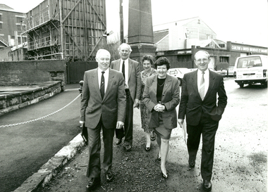
Photograph - Photograph - Black and White, Premier Joan Kirner visits the Ballarat School of Mines, August 1991, 08/1991
Before her marriage to Ron Kirner, Joan Hood taught at the Ballarat Girls' Junior Technical School in the late 1950s. The Girls' school was a division of the Ballarat School of Mines. After entering politics Joan Kirner was Minister for Education (1988) and Premier of Victoria (1990 to 1992). In 1992 Premier of Victoria Joan Kirner visited her former workplace to officially open and name four new facilities, marking stage 2 of the school's State Works and Services Development Project. Honoured in the naming ceremony was the late Albert Steane, the late Kenneth Fleckoe and Mr Jack Barker, President of the Ballarat School of Mines. The fourth facility was the recently opened carpentry and joinery complex. Mrs Kirner said naming the building in honour of the three men would act as a continual reminder of their contribution to education in Australia and what they have passed on to future generations. She said the Government and the State Training Board saw the college as not only one that was most important to Victoria but also nationally and internationally. A group of 5 people walking along Ballarat's Lydiard Street South. The former Ballarat Brewery in the background is in the process of being demolished to make way for an expansion of the SMB campus. Left to right: Peter Shiells, E.J. (Jack) Barker, Winsome Barker, Premier of Victoria Joan Kirner, Frank Sheehan MLA (Labor State Member for Ballarat South). joan kirner, joan hood, ballarat junior technical girls' school, e.j. barker, peter shiells, frank sheehan -
 Federation University Historical Collection
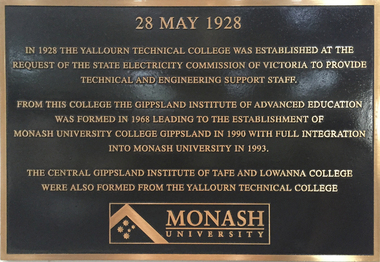
Photograph - Photograph - Colour, Clare Gervasoni, Historical Plaques at Federation University Australia Gippsland Campus
The following information was the preface of the 1985 GIAE handbook: The Gippsland institute of Advanced Education was established by an Order-in-Council in September, 1968, but, owes its origin to engineering diploma courses established in 1928 to service the developing electrical industry. The Council of the Institute includes members of the Gippsland community who are prominent in industry, commerce, education and the professions, the Director of the institute, the representative of the academic staff, of general staff, of students and of the Convocation of the Institute. In 1972 the Institute occupied the first of its permanent buildings on a large campus in rural surroundings near the township of Churchill, ten kilometres south of Morwell and one hundred and sixty kilometres east of Melbourne. Engineering laboratories are temporarily located in buildings on the site of the Yallourn College of TAFE at Newborough and they will be consolidated on the Churchill campus by the end on 1985. In 1974 new buildings were completed under a self-help program to house the School of Visual Arts. A building complex to provide the first stages of the permanent library and the Union, and accommodation for the School of Business and Social Sciences was completed in 1976. An Education building, an Applied Science building and student residential buildings for 108 student places were completed at the beginning on 1976. The Binishell, a multi-purpose facility was completed in 1980. On its establishment, the Institute assumed responsibility for the diploma courses which were previously offered by the Yallourn Technical College. These were diploma in Civil, Electrical, and Mechanical Engineering, Applied Chemistry, and Business, all of which were recognised by the appropriate professional bodies. The Gippsland Institute of Advanced Education is the only centre of Higher Education east of Melbourne and offers a range of vocational courses at associate diploma, diploma, degree, graduate degree and master levels to meet the educational needs of the Gippsland regions. The institute also has a very large commitment to a program on external studies. Federation University Australia was established on 1 January 2014. Formerly known as the University of Ballarat, its enabling legislation was the University of Ballarat Amendment (Federation University Australia) Act 2013. Although formally created as a University in 1994, the University of Ballarat had a lineage back to 1870 with the establishment of the School of Mines Ballarat, making it the third institution of higher learning to be established in Australia and the first to be established in regional Australia. On 1 January 1994, Ballarat University College became the University of Ballarat and in 1998 the University merged with three TAFE Institutes to become a dual sector institution with multiple campuses. On 1 January 2014, the University of Ballarat amalgamated with the Monash University Gippsland Campus to form Federation University Australia. The Gippsland Campus also had a long lineage dating back to 1928 with the establishment of the Yallourn Technical School which became a predecessor institution to the Gippsland College of Advanced Education formed in 1968. In 1990, it was renamed the Monash University College and in 1993 became the Gippsland Campus of Monash University.4 plaques placed on the wall of 'The Knuckle' at Federation University Gippsland Campus. .1) Brown and brass coloured plaque commemorating the establishment of Yallourn Technical School. .2) Brass plaque commemorating the opening of the Gippsland Institute of Advanced Education. .3) Brass plaque commemorating the affiliation between Gippsland Institute of Advanced Education and Monash University. .4) Plaque commemorating .1) 28 May 1928 In 1928 the Yallourn Technical College was established at the request of the State Electricity Commission of Victoria to provide technical and engineering support to staff. From this College the Gippsland Institute of Advanced Education was formed in 1968 leading to the establishment of Monash University College Gippsland in 1990 with full integration into Monash University in 1993. .2) The Gippsland Institute of Advanced Education was officially opened on the 20th November, 1976 by Senator The Honourable J.L. Carrick Minister of State for Education and The Honourable L.H.S. Thompson C.M.G., M.P. Deputy-Premier of Victoria and Minister of Education. .3) Monash University Gippsland Institute of Advanced Education At this campus on 24 February 1989 and in the presence of the Honourable John Dawkins, the Federal Minister for Employment, Education and Training, and representatives of the Gippsland community, affiliation documents were signed and exchanged. On 01 July 1990, the Gippsland Institute became the Monash University College Gippsland as a constituent of Monash University. Professor Tom Kennedy Professor Mal Logan Pro Vice-Chancellor Vice-Chancellor .4) Monash University Gippsland Campus On 25 August 1992 the Advisory Council of Monash University College Gippsland endorsed the integration of the University College into Monash University from 1 January 1993. Professor Tom Kennedy Mr Crofton Hatsell Pro Vice-Chancellor Chair, Advisory Council Professor Mal Logan, Vice-Chancellorfederaton university, yallourn technical college, state electricity commission of victoria, gippsland institute of advanced education, monash university college gippsland, monash university, central gippsland institute of tafe, lowanna college, lindsay thompson, j.l. carrick, tom kennedy, crofton hatsell, mal logan, john dawkins, gippsland institute, gippsland campus collection -
 Federation University Historical Collection
Photograph - Photograph - Colour, Federation University Gippsland Campus, c1995
The following information was the preface of the 1985 GIAE handbook: The Gippsland institute of Advanced Education was established by an Order-in-Council in September, 1968, but, owes its origin to engineering diploma courses established in 1928 to service the developing electrical industry. The Council of the Institute includes members of the Gippsland community who are prominent in industry, commerce, education and the professions, the Director of the institute, the representative of the academic staff, of general staff, of students and of the Convocation of the Institute. In 1972 the Institute occupied the first of its permanent buildings on a large campus in rural surroundings near the township of Churchill, ten kilometres south of Morwell and one hundred and sixty kilometres east of Melbourne. Engineering laboratories are temporarily located in buildings on the site of the Yallourn College of TAFE at Newborough and they will be consolidated on the Churchill campus by the end on 1985. In 1974 new buildings were completed under a self-help program to house the School of Visual Arts. A building complex to provide the first stages of the permanent library and the Union, and accommodation for the School of Business and Social Sciences was completed in 1976. An Education building, an Applied Science building and student residential buildings for 108 student places were completed at the beginning on 1976. The Binishell, a multi-purpose facility was completed in 1980. On its establishment, the Institute assumed responsibility for the diploma courses which were previously offered by the Yallourn Technical College. These were diploma in Civil, Electrical, and Mechanical Engineering, Applied Chemistry, and Business, all of which were recognised by the appropriate professional bodies. The Gippsland Institute of Advanced Education is the only centre of Higher Education east of Melbourne and offers a range of vocational courses at associate diploma, diploma, degree, graduate degree and master levels to meet the educational needs of the Gippsland regions. The institute also has a very large commitment to a program on external studies. Federation University Australia was established on 1 January 2014. Formerly known as the University of Ballarat, its enabling legislation was the University of Ballarat Amendment (Federation University Australia) Act 2013. Although formally created as a University in 1994, the University of Ballarat had a lineage back to 1870 with the establishment of the School of Mines Ballarat, making it the third institution of higher learning to be established in Australia and the first to be established in regional Australia. On 1 January 1994, Ballarat University College became the University of Ballarat and in 1998 the University merged with three TAFE Institutes to become a dual sector institution with multiple campuses. On 1 January 2014, the University of Ballarat amalgamated with the Monash University Gippsland Campus to form Federation University Australia. The Gippsland Campus also had a long lineage dating back to 1928 with the establishment of the Yallourn Technical School which became a predecessor institution to the Gippsland College of Advanced Education formed in 1968. In 1990, it was renamed the Monash University College and in 1993 became the Gippsland Campus of Monash University. Large photograph adhered to foamcore showing an aerial view of the Federation University Gippsland Campus at Churchill, Victoria as it was c1995.churchill, gippsland campus, gippsland institute of advanced education, federation university, yallourn, morwell, binishell -
 Federation University Historical Collection
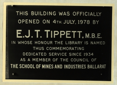
Photograph, Ballarat School of Mines Library Plaques, c1970s and 1980s
The Ballarat School of Mines is a predecessor organisation of Federation University Australia.Black and white photographThis building was officially opened on 4th July, 1978 by E.J.T. Tippett, M.B.E. in whose honour the library was named thus commemorating dedicated service since 1934 as a member of the Council of the School of Mines and Industries Ballarat Stamp Battery The stamp battery for treating gold ores was first intriduced in California. A heavy iron stamp is raised on a cam and let fall so that its weight causes the quartz which is held in the mortar box. This three head battery was installed in the mining laboratory of The School of Mines, Ballarat in 1898 and crused many hundreds of tons of quartz. It was reected on this site to commeorate the centenary of the School of Mines in 1870. School of Mines & Industries Ballarat Established - 1870 Stage one of The Vocational Skills Centre was officially opened by The Hon. Robert Fordham M.P. Minister of Education on 29th April 1983 P.R. Shiells K.J. Flecknoe Principal President The School of Mines and Industries Ballarat Established - 1870 This plaque commemorates the opening of the Hairdressing School on 9 March 1983 by Peter Cutter, B. Comms, M. Ed. General Manager - Programs, TAFE Board School of Mines and Industries Ballarat Ltd Land Laboratory officially opened by Dr D.F. Smith Director of Agriculture on 12th November 1980. School of Mines & Industries Ballarat Amenities Building was officially opened by His excellency The Hon. Sir Henry Winneke K.C.M.G., K.C.V.O., O.B.E.. K. St. J., O.C., Governor of Victoria on 7th October 1981 G.H. Beanland K.J. Beanland Principal President This room is known as the Yates Geological Centre in recognition of a professional lifetime of service from 1920=1962 as' head of Geology in The SChool of Mines and Industries Ballarat by Harold Yates M.Sc Plaque presented by former students This stone was laid by The Hon. Alexr J. Peacock Minister of Public Instruction April 14th 1899 Abdrew Anderson, Presidentbuildings, ballarat school of mines, smb campus, premier of victoria, plaque, e.j.t. tippett library, tippett learning research centre, smb library, ballarat school of mines library, e.j. tippett, smb foundation stone, smb stamp battery plaque, geology centre - yates, yates geological centre, smb amenities building opening, smb land laborarory opening, smb hairdressing school opening, smb vocational centre (stage 1) opening, smb e.j. tippett library opening, former ballarat gaol national trust plaque, former ballarat supreme court national trust plaque, smb buildings - administration national trust plaque, foundation of technical education in australia, ballarat school of mines foundation stone, yates geology centre, amenities building, land laboratory, former ballarat gaol, former ballarat supreme court, courthouse theatre, stamp battery, stamper battery, centenary, anniversary, mortar box, peter shiells, ken flecknoe, vocatonal skills centre, haidressing school, peter cutter, museum building, former wesley church, henry winneke, graham beanland, harold yates, alexander peacock, andrew anderson, a building, administration building -
 Marysville & District Historical Society
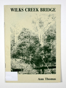
Book, Wilks Creek Bridge, 1993
A history of the Wilks Creek Bridge and its connection to the Yarra TrackPaperback. Front cover has an old photograph of the Wilks Creek Bridge.Dear Reader, The pen has only to select one of the many stages of building old Yarra Track,/ for a colorful story subject. The Track, first established in the early 1860's to/ serve goldseekers making their hazardous way to the rich Wood's Point goldfields,/ extended some 160km from Eltham - in Melbourne's northern region to Woods/ Point in the eastern ranges. I hope a glimmer of the excitement of those times comes through as I draw/ your attention to old Wilks Creek bridge and its picnic spot to be found 3.5km/ west of Marysville. Once part of Yarra Track and now superseded by a modern/ roadway alongside, the old bridge with its solid masonry walls either side of the/ cold, pure stream makes a pleasing scene for the visitor. With much pleasure/ I dedicate this narrative to Marysville and District Historical Society./ Ann Thomas Stamp of Marysville & District / Historical Society Inc / P.O. Box 22 / Marysville 3779wilks creek, marysville, yarra track, victoria, history, local history -
Federation University Historical Collection
Photograph, Plaque for Stage One of the Vocational Skills Centre, 1983, c1983
Colour photographSchool of Mines and Industries Ballarat Established - 1870 Stage one of The Vocational Skills Cente was officially opened by the Hon. Robet Fordham M.P. Minister of Education in 29th April 1983 P.R. Shiells K.J. Flecknoe Principal Presidentbuildings, ballarat school of mines, smb campus, premier of victoria, plaque, vocational skills centre, stage one of the vocational skills centre, robert fordham, peter shiels, ken flecknoe -
 Eltham District Historical Society Inc
Photograph, Sherbourne Primary School, Outlook Crescent, Briar Hill, c.1971-1972, 1971-1972c
Two black and white photographs; one internal and one external showing construction at bricklaying stagesherbourne primary school, schools, outlook crescent, briar hill, buildings, construction -
 Sunshine and District Historical Society Incorporated
Photographs (1928), 'QUARTER MILE' BRIDGE Construction, 1928
One man lost his life during the building of this bridge. The bridge was constructed by the Victorian Railways between 1927 to 1929 to carry a new double track goods line. This enabled trains from all parts of the state except Gippsland to have direct access to the Tottenham marshalling and sorting yards. These yards were constructed in the 1920's to relieve congestion in the Melbourne Yard near Spencer Street station. The congestion was being caused by the construction of suburban passenger platforms associated with the electrification of the suburban railway network. Initially the bridge was for goods trains but during the Second World War it was also used by troop trains. When the standard gauge line was built in 1962 all trains to Albury and Sydney have used this route, thus avoiding travelling through Essendon and Pascoe Vale on the suburban tracks. The standard gauge track across the bridge took the place of one of the broad gauge tracks so broad gauge trains crossing the bridge in either direction have to now use the same track. The bridge is 1,257 feet (383.13 metres) long and 180 feet (54.86 metres) above the water level. It is just 63 feet (19.2 metres) short of a quarter mile in length between abutments. There is a similar bridge on the same railway line crossing the Moonee Ponds Creek between Gowenbrae and Glenroy, however it is smaller at 1060 feet (323.08 metres) length and 115 feet (35.05) height.The bridge is now Victorian Heritage Registered under Number: H1197, and Heritage Overlay Numbers HO5, and HO107. On the Heritage Register it is named RAIL BRIDGE (ALBION VIADUCT). According to the Heritage Report the bridge is scientifically and architecturally important because of its large size, and because of the cost effective design features such as two girders per span (one for each track), the K bracing in the towers, and the broad flange beams as columns. When it was being built it was the largest trestle bridge in Australia, and until the Sydney Harbour bridge was constructed it was the highest railway bridge.Five B&W yellowing photos showing stages of construction of the Maribyrnong River Viaduct known as the Trestle Bridge but mainly known locally as the QUARTER MILE BRIDGE. It is a railway only bridge which runs over the Maribyrnong River between Sunshine North and Keilor East. A sixth image, which is not part of this set of photos, is included to show what the completed bridge looks like. -
 RMIT Design Archives
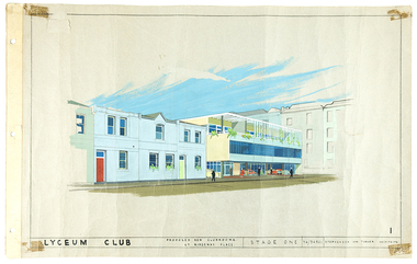
Architectural drawings, Lyceum Club: Proposed new Clubrooms at Ridgeway Place: Stage one
As a Principal of Stephenson and Turner, Ellison Harvie?s 1959 design for the proposed new club rooms of the Lyceum Club, Melbourne has an elegance typical of late 1950s modernism. Harvie attended Swinburne Technical College and then, from 1925 to 1928, the Melbourne University Architectural Atelier where she excelled, becoming the first woman to receive a diploma of architectural design from that institution. Harvie was an advocate for the professional development of women in architecture and was a mentor to younger women. She was President of the Lyceum Club from 1963 to 1965. The Club had been established in 1912 for women graduates and those who had distinguished themselves in public service. The watercolour perspective is held in the archive of Berenice Harris, whose last major project was a renovation and extension to the Lyceum Club in the 1980s.watercolour, paper -
 Kew Historical Society Inc
Photograph, J F C Farquhar, Bird's Eye View Looking North, 1891
At the beginning of the 1890s, the Kew businessman and Town Councillor, Henry Kellett, commissioned J.F.C. Farquhar to photograph scenes of Kew. These scenes included panoramas as well as pastoral scenes. The resulting set of twelve photographs was assembled in an album, Kew Where We Live, from which customers could select images for purchase.The preamble to the album describes that the photographs used the ‘argentic bromide’ process, now more commonly known as the gelatine silver process. This form of dry plate photography allowed for the negatives to be kept for weeks before processing, hence its value in landscape photography. The resulting images were considered to be finely grained and everlasting. Evidence of the success of Henry Kellett’s venture can be seen today, in that some of the photographs are held in national collections.It is believed that the Kew Historical Society’s copy of the Kellett album is unique and that the photographs in the book were the first copies taken from the original plates. It is the first and most important series of images produced about Kew. The individual images have proved essential in identifying buildings and places of heritage value in the district.This panoramic view was probably taken from the roof of Xavier College. It invites the viewer to look down on the buildings and streets of Kew, and across to the distant horizon. Mansions and solid bourgeois villas dominate the view of Charles and Wellington Streets. The imposing spires of the Presbyterian and Methodist Churches, built in one of the highest areas of Kew, can be seen in the distance. In the foreground, the photographer includes three significant mansions: Molina, Roxeth and Elsinore. Molina, in the foreground, and the group of weatherboard buildings in its yard was used at this stage for the privately operated ‘Kew High School’ (founded 1872). Roxeth, the home of Herbert Henty can be identified by its distinctive four-sided tower. All three buildings are now part of Trinity Grammar. Other built structures observable in the photograph include Wilton (now the Kew RSL), designed by Guyon Purchas for Dr William Walsh in 1886, and the only known image of the Prospect Hill Hotel prior to the renovation of 1935. Bird's Eye View Looking Northkew illustrated, kew where we live, photographic books, henry kellett -
 Nillumbik Shire Council
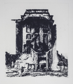
Print (drypoint): Rick AMOR (b.1948 Melbourne, AUS), Rick Amor, 'The Ruin' from 'The Baldessin & Friends' commemorative folio, 2016
Painter, printmaker and sculptor Rick Amor is one of Australia's most distinguished senior artists. He was a good friend of the late George Baldessin and three times Archibald Prize winner Clifton Pugh, having lived and worked at Pugh's property, Dunmoochin in Cottles Bridge, Nillumbik during the 1980s and 90s. George Baldessin (1939-1978) was born in San Biagio di Callalta, in the Veneto in Northern Italy and arrived in Australia ten years later. A printmaker and sculptor he built his bluestone studio at St Andrews (Nillumbik) in 1971 with his partner Tess and the three Hails brothers, Rob, Doug and Don. Made of recycled materials the studio today contains all of George’s equipment including the large press, which he modelled himself with the help of Neil Jeffrey (Enjay Presses). George won many prizes throughout his career and is represented in many of Australia's public art collections including his famous 'Pears' sculpture in front of the National Gallery of Australia, Canberra. In 1975 he represented Australia in the Sao Paulo Biennale, before living and working in Paris until his return to St Andrews in 1977. In 1978 George was killed in a car accident aged 39 years. In 2001 Tess returned to St Andrews to reclaim the run-down studio and reconstitute it as The Baldessin Press & Studio - a printmaking retreat. It operates in George’s memory, so that artists may continue to create, perpetuating the generous spirit of George. 'The Ruin' is one of eight prints in the 'Baldessin & Friends commemorative folio. The folio was conceived by Tess Edwards as a fundraising initiative in celebration of the The Baldessin Press & Studio's fifteen year anniversary, and as a way to honour George Baldessin's memory. The folio is a unique coming together of seven very different and acclaimed artists who are connected by their friendship to the missing eighth member, George Baldessin. The Baldessin Press & Studio is a not-for-profit organisation created in memory of the late George Baldessin (1939-1978), whose original studio is now open to the public for creative use and as a practical legacy to living artists. The Studio is located in St Andrews, Nillumbik. Rick Amor has been an ardent supporter of the Baldessin Press & Studio and a great patron of living artists. In 2014 the Press partnered with Amor and the State Library of Victoria to create The Amor Residency at The Baldessin Press & Studio, which is part of the Library's annual fellowship program. 'The Ruin' was based on a plein air painting done by Rick Amor on a trip to Broken Hill in 2001 and reflects on death and the passing of time so eloquently portrayed by the industrial ruins of NSW. In the tradition of a Piranesi, the work emphasises the transience of life and the triumph of time. Black and white drypoint etching in which a small figure, a traveller; located bottom left, points to a large crumbling edifice (building), a stage like space in the background. Ed.14/25baldessin, print, drypoint, amor, 2018 ekphrasis, ruin, etching, ekphrasis2018 -
 Port Fairy Historical Society Museum and Archives
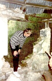
Photograph, Arthur Hoey Albert Rd 1992, 1992
Arthur Hoey, a Port Fairy Builder inspecting the ruins of a cottage on Albert Road. Arthur went on to restore the cottage. Research done by family found that the house a t one stage belonged at one time to Chidley a photographer . Further information also to hand mentions the area being used by Stan Chidley for a "scent farm". Several types of herbs and flowers were being grown thereColoured photograph of Arthur Hoey standing in a hole in the wall of the cottagecottage, building, home, house, albert road, scent farm -
 Puffing Billy Railway
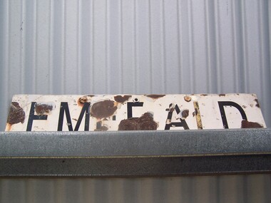
Emerald Station Sign
... building underwent stage one of an internal restoration to its... building underwent stage one of an internal restoration to its ...Station Sign - Emerald Emerald Station is situated on the Puffing Billy Railway in Victoria, Australia. It was opened with the Railway on 18 December 1900 and comprised a platform track and a loop siding. A passing loop was added between the two a few years later. There was also a spur siding off the Down end of No. 3 Road. Two standard 12 ft by 20 ft timber portable station buildings with a Van Goods Shed between (all adjoining) were provided on the platform and a Goods Shed on the No. 3 Road loop siding. Other buildings included Tea Rooms, lamp room and toilets along with a cattle race and loading bank. The station building was later reduced in length by one of the portables which housed the General and Ladies' waiting rooms. Emerald today remains very similar to the early days, but has had other Roads added into a Carriage Workshops, a turntable and storage sidings. Also, a Signal and Telegraph Branch depot in the form of a large Goods Shed and a multi-purpose yard building in the form of a Locomotive Depot administration building have been added. During 2009, the station building underwent stage one of an internal restoration to its former glory. ref: https://en.wikipedia.org/wiki/Emerald_railway_station,_Victoria photos at http://www.vicrailstations.com/Gembrook/Emerald/Emerald.html Historic - Victorian Railways Station sign used at Emerald Station Station Sign - Emerald Metal rectangle Station Name Sign with white enamel back ground and black lettersEmeraldstation sign, puffing billy, emerald station -
 Hume City Civic Collection
Photograph, Royal Hotel
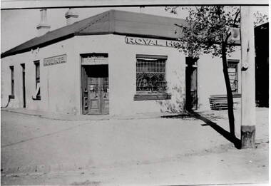
This is an image of the original single storey Royal Hotel building which was on the corner of Brook and Evans Streets. In the 1930s the single storey structure was demolished after a fire and replaced with a double storey Art Deco red brick building, which still stands on the same site.At one stage there were four hotels in Evans Street between Station Street and Brook Street. At some stage the Millett family owned them. The Royal and the Olive Tree (formerly the Railway) hotels remain on their original site but not in their original appearance.A black and white photograph with a cream border of a single storey hotel building with a headlight window on the RHS of the corner entry doorway, which also has lead light windows. A young tree and power pole are seen on the RHS of the image. hotels, royal hotel, s.winter, t. millett -
 Hume City Civic Collection
Photograph
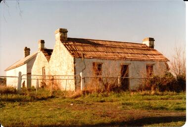
This is a photograph of one of the many stone ruins of buildings which can be seen in the Sunbury district and surrounding areas. This series of 13 photographs show various views of one of the remaining uninhabited stone cottages which were built in the early days of the district's settlement.A coloured photograph of a stone cottage with a wooden shingle roof and its weatherboard and corrugated iron out building. A valley between two sections of the building suggests it has been built in stages. Three chimneys are visible and the cottage has three 12 paned sash windows with a doorway in the centre of the front. There is a cyclone wire fence and gate across the front and the garden is overgrown.stone structures, shingle roofs, george evans collection -
 Hume City Civic Collection
Photograph
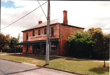
Since it was built in the 1860s the two storey brick building has had a number of commercial uses including butter and ice making, a general store, an equestrian store, an art gallery, a community Christian centre and a health studio. It has apparently been built in two stages because one section of the brickwork has a smoother finish.A coloured photograph of a two storey brick building with a slate roof. There is a shop front on the ground floor and 5 windows are on the 2nd storey. A verandah extends across the front of the lower storey to the edge of the footpath.butter and ice making, johnston, george, james, william, george evans collection -
 Kew Historical Society Inc
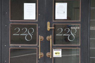
Photograph - Photographs (series), Richard Bowen, Sunninghill, 228 Cotham Road, 07/02/2020
'Sunninghill' at 228 Cotham Road (Kew) is an historically significant building due to its associations with Joseph Thomas (Bland) Holt (1851-1942), theatre entrepreneur and actor who lived at the house following his retirement in 1909. Sunninghill (aka Sunning Hill) was one of his residences in Victoria (also 'The Anchorage' at Sorrento). Following Holt's death at Sunninghill on 28 June 1942, the house was left to his wife. After her death the house was bequeathed to Lucy Coppin, daughter of George Coppin. The 'Shakespeare Window' in the State Library of Victoria was at one stage installed in the house. References 'Death of Mr Bland Holt: Great exponent of melodrama', The Argus, 30 June 1942, p. 3. Shoesmith D, 'Holt, Joseph Thomas (Bland) (1851-1942)', Australian Dictionary of Biography, Vol 4, 1972. 'The Shakespeare Window', State Library of Victoria website.Exterior photographs (digital) of Sunninghill, 228 Cotham Road, Kew VIC 3101. sunninghill - 228 cotham road - kew (vic), joseph thomas (bland) holt, lucy coppin -
 Kew Historical Society Inc
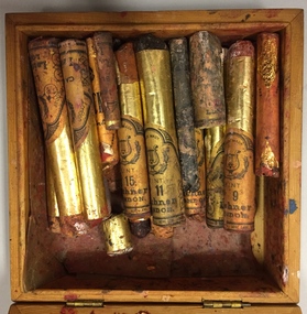
Equipment - Theatre Supplies, Boxed Greasepaint Sticks, c.1975
The Rockingham Red Cross Centre in Kew provided convalescence and rehabilitation for war veterans suffering nervous conditions resulting from the Second World War. The building had been given to the Australian Red Cross by the owner of the house, Mrs Syme in 1940. In the early days of the centre, patients performed plays for fellow patients and staff members. This small box of theatrical makeup, or greasepaint, would have been used at the Centre on one or more of these occasions. The donor, Rosemary Lade, worked at the Centre as an occupational therapist, 1971-2 and 1974-7. During these years, play readings were held, but performances were not staged. The Rockingham Red Cross Centre closed in 1977, and following its closure, the donor retrieved the box of greasepaints from the Occupational Therapy Department. A box of greasepaint from the Rockingham Red Cross Centre, Kew. Square wooden box, containing sticks of greasepaint used for theatrical makeup. The used sticks of greasepaint are wrapped in foiled paper, printed with information about the colour and the maker/retailer: L. Leichner (London) Ltd. Leichner House, 30/32 Acre Lane, / London, S.W.2. theatrical makeup, greasepaint, rockingham, rockingham red cross centre, syme family, rosemary lade, occupational therapy - theatre -
 Kew Historical Society Inc
Plan, Melbourne and Metropolitan Board of Works, Melbourne & Metropolitan Board of Works : Borough of Kew : Detail Plan No.1294 & 1295, 1904
The Melbourne and Metropolitan Board of Works (MMBW) plans were produced from the 1890s to the 1950s. They were crucial to the design and development of Melbourne's sewerage and drainage system. The plans, at a scale of 40 feet to 1 inch (1:480), provide a detailed historical record of Melbourne streetscapes and environmental features. Each plan covers one or two street blocks (roughly six streets), showing details of buildings, including garden layouts and ownership boundaries, and features such as laneways, drains, bridges, parks, municipal boundaries and other prominent landmarks as they existed at the time each plan was produced. (Source: State Library of Victoria). This plan forms part of a large group of MMBW plans and maps that was donated to the Society by the Mr Poulter, City Engineer of the City of Kew in 1989. Within this collection, thirty-five hand-coloured plans, backed with linen, are of statewide significance as they include annotations that provide details of construction materials used in buildings in the first decade of the 20th century as well as additional information about land ownership and usage. The copies in the Public Record Office Victoria and the State Library of Victoria are monochrome versions which do not denote building materials so that the maps in this collection are invaluable and unique tools for researchers and heritage consultants. A number of the plans are not held in the collection of the State Library of Victoria so they have the additional attribute of rarity.Original survey plan, issued by the MMBW to a contractor with responsibility for constructing sewers in the area identified on the plan within the Borough of Kew. The plan was at some stage hand-coloured, possibly by the contractor, but more likely by officers working in the Engineering Department of the Borough and later Town, then City of Kew. The hand-coloured sections of buildings on the plan were used to denote masonry or brick constructions (pink), weatherboard constructions (yellow), and public buildings (grey).The streets and built structures in MMBW Detail Plan 1294 & 1295 were surveyed in 1903 and released to contractors in 1904. This plan is one of two in the collection where the lithographers amalgamated two separate plans. Both plans include sections of Studley Park. Dominating the south and west corners of Kew Junction are the Clifton and Kew Hotels. The Kew Hotel, owned by Patrick O’Shaughnessy was one of the oldest in Kew. MMBW plans were amended over time to take account of new subdivisions such as that which created Merrion Place. Of the four mansions shown in Studley Park Road, three remain – ‘Field Place’, the home of Frances Henty, ‘Leaghur’ and ‘Darley’. ‘Byram’ (later ‘Goathland’, then ‘Tara Hall’) was an architectural marvel. Designed in 1888 by E.G. Kilburn for the paper magnate George Ramsden, it was demolished in 1960. While an earlier sale of the southern section of Byram had created Tara Avenue in 1927, the demolition of the house in 1960 enabled the extension of Tara Avenue northward.melbourne and metropolitan board of works, detail plans, mmbw 1294, mmbw 1295, cartography -
 Kew Historical Society Inc
Plan, Melbourne & Metropolitan Board of Works : Borough of Kew : Detail Plan No.1296, 1904
The Melbourne and Metropolitan Board of Works (MMBW) plans were produced from the 1890s to the 1950s. They were crucial to the design and development of Melbourne's sewerage and drainage system. The plans, at a scale of 40 feet to 1 inch (1:480), provide a detailed historical record of Melbourne streetscapes and environmental features. Each plan covers one or two street blocks (roughly six streets), showing details of buildings, including garden layouts and ownership boundaries, and features such as laneways, drains, bridges, parks, municipal boundaries and other prominent landmarks as they existed at the time each plan was produced. (Source: State Library of Victoria)This plan forms part of a large group of MMBW plans and maps that was donated to the Society by the Mr Poulter, City Engineer of the City of Kew in 1989. Within this collection, thirty-five hand-coloured plans, backed with linen, are of statewide significance as they include annotations that provide details of construction materials used in buildings in the first decade of the 20th century as well as additional information about land ownership and usage. The copies in the Public Record Office Victoria and the State Library of Victoria are monochrome versions which do not denote building materials so that the maps in this collection are invaluable and unique tools for researchers and heritage consultants. A number of the plans are not held in the collection of the State Library of Victoria so they have the additional attribute of rarity.Original survey plan, issued by the MMBW to a contractor with responsibility for constructing sewers in the area identified on the plan within the Borough of Kew. The plan was at some stage hand-coloured, possibly by the contractor, but more likely by officers working in the Engineering Department of the Borough and later Town, then City of Kew. The hand-coloured sections of buildings on the plan were used to denote masonry or brick constructions (pink), weatherboard constructions (yellow), and public buildings (grey). This area was once known as O’Shaughnessy’s Paddock. O’Shaughnessy was the licensee of the Kew Hotel. The ‘Paddock’ or farm was for many years the closest farm to Melbourne. By 1903, when this plan was surveyed and lithographed, little of the farm remained. The area is dominated by a ‘clay hole’, on the site of the current Foley Reserve. It was used by Smart’s Brickyard from the 1880s until 1911, when the Council purchased it for a rubbish dump. It is notable as the site is one of the few industrial operations to have existed in Kew. By 1903, urban development was characterised by larger houses fronting Barkers Road and brick and weatherboard villas in Foley Street. Nearer the pit, weatherboard houses predominated. Foley Street bisected the triangular block and continued right to Denmark Street. At this stage, a house impeded the through road, only allowing access via a right of way to High Street.melbourne and metropolitan board of works, detail plans, mmbw 1296, cartography -
 Kew Historical Society Inc
Plan, Melbourne & Metropolitan Board of Works : Borough of Kew : Detail Plan No.1297, 1904
The Melbourne and Metropolitan Board of Works (MMBW) plans were produced from the 1890s to the 1950s. They were crucial to the design and development of Melbourne's sewerage and drainage system. The plans, at a scale of 40 feet to 1 inch (1:480), provide a detailed historical record of Melbourne streetscapes and environmental features. Each plan covers one or two street blocks (roughly six streets), showing details of buildings, including garden layouts and ownership boundaries, and features such as laneways, drains, bridges, parks, municipal boundaries and other prominent landmarks as they existed at the time each plan was produced. (Source: State Library of Victoria)This plan forms part of a large group of MMBW plans and maps that was donated to the Society by the Mr Poulter, City Engineer of the City of Kew in 1989. Within this collection, thirty-five hand-coloured plans, backed with linen, are of statewide significance as they include annotations that provide details of construction materials used in buildings in the first decade of the 20th century as well as additional information about land ownership and usage. The copies in the Public Record Office Victoria and the State Library of Victoria are monochrome versions which do not denote building materials so that the maps in this collection are invaluable and unique tools for researchers and heritage consultants. A number of the plans are not held in the collection of the State Library of Victoria so they have the additional attribute of rarity.Original survey plan, issued by the MMBW to a sewage contractor with responsibility for constructing sewers in the area identified on the plan within the Borough of Kew. The plan was at some stage hand-coloured, possibly by the contractor, but more likely by officers working in the Engineering Department of the Borough and later Town, then City of Kew. The hand-coloured sections of buildings on the plan were used to denote masonry or brick constructions (pink), weatherboard constructions (yellow), and public buildings (grey). This plan of Kew encompasses the area bounded by Barkers Road, High Street and Stevenson Street. Because of the angle created by High Street, a number of houses on the northern side of High Street are shown. The area is dominated by one of the great original landholdings in Kew, described here as the ‘Findon Paddock’. ‘Findon’, the house from which the name of the paddock was taken fronts Stevenson Street and was clearly a rambling structure. The best-known occupant of Findon was Henry ‘Money Miller’ who bought the house in 1871. Miller was a member of Victoria’s first parliament and assisted in the framing of its constitution. Findon was to be subdivided as early as 1912, when the Findon Subdivision was advertised to be sold by auction. In the plan of the subdivision, the original house is not shown, so, presumably it had previously been demolished. Fincham & Son moved the organ, built by Henry Willis, which was installed in the house, first to ‘Whernside’ in Toorak, and later to the Box Hill Methodist Church.melbourne and metropolitan board of works, detail plans, mmbw 1297, cartography, kew (vic.) — municipal collection